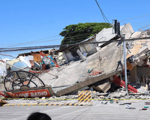
The Philippine Space Agency (PhilSA) has identified about 138 hectares of possible landslide areas in Sarangani and Davao Occidental using satellite images following the magnitude 7.8 earthquake that struck Mindanao on June 8.
The mapped areas cover 11 barangays in Glan, Sarangani, and Jose Abad Santos, Davao Occidental, and were identified by comparing pre- and post-earthquake satellite images showing significant vegetation loss.
PhilSA said the findings are subject to ground validation but will help disaster authorities prioritize response and monitoring efforts.
The June 8 earthquake has so far left 78 people dead, 1,339 injured, and 30 missing, while more than 1.6 million residents have been affected.
Government reports also showed that about 88,000 people remain displaced, and over 84,000 houses were damaged by the disaster.
Source: PhilNews24 | June 22, 2026
SPACE AGENCY IDENTIFIES QUAKE-TRIGGERED LANDSLIDES IN MINDANAO


Latest from News

President Ferdinand Marcos Jr. has approved an additional P3 billion to strengthen the government’s repatriation and

Transportation Secretary Giovanni Lopez urged ASEAN partners and development institutions to invest in and help accelerate

The Philippine National Police will implement full security measures for the June 28 White Ribbon Movement

The Philippine Drug Enforcement Agency (PDEA) said 10,540 drug personalities have participated in the government’s Balay

The Department of Public Works and Highways (DPWH) is encouraging the public to report unfinished, damaged,